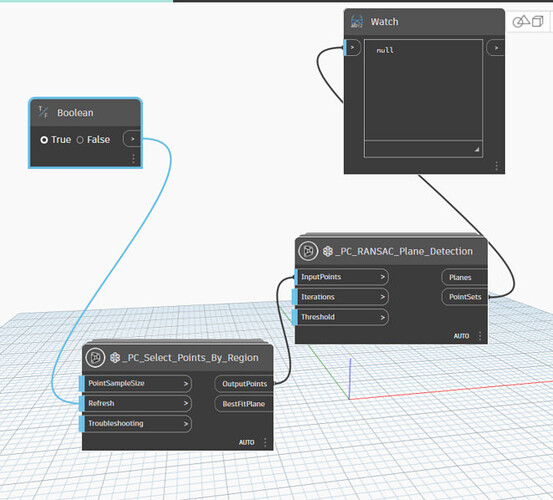
Hello, everyone. I am trying to work with Pointclouds using Revit and Dynamo. My goal is to detect and draw pipes from point cloud data. So, to start working with it, I tried to Sastrugi package created by @Ewan_Opie but the node for selecting points by region is not working. It’s just returning null value. I looked into some online resources and they all used “select points in view” but it is deprecated in the new version. I have no idea what to do right now, can anyone please direct me towards any helpful direction? I am new to this, so any relevant advice is appreciated.
Have you tried enabling the ‘troubleshooting’ input?
Yes. I selected the pointcloud, clicked a corner of the viewcube, and reloaded the dynamo script again. It still shows the same Null value.
*I am sorry to ask this, but I am assuming the cube in the corner is called viewcube. (Please correct me if I am doing it wrong.)

Think you’re supposed to pick corners in the view, but am not sure and don’t have a test dataset.
I tried to pick corners in the view, but it isn’t working.
Do you have a test dataset? Something with say 1000 points not 100000000?
I am sending you a cropped version of my test data.
Link: Demo - Google Drive
Please have a look. Thanks a lot in advance.
Revit build?
Revit 2023
If you open up the ndoe copy the contents, and paste it into your workspace you’l see you have an error indicating you’ve exceeded the extents of the Revit geometry engine. Not sure there is a way around that without cleaning the ponit data to be closer to the origin.
Thank you for your diagnosis, @jacob.small. But I used “origin to internal origin” while importing to get the data closer to the internal origin. Can you explain a bit more on this? Really appreciate your inputs here.
Relinked into a different template (using metric now) and it’s working for me now.
When a Sastrugi package doesn’t work you want to open it up, copy the contents, paste it into the workspace, see what detailed errors pop up, and address those.
Working with point clouds in Dynamo is a ‘front of the adoption curve’, and in general wouldn’t be the way I’d go about it if I had to build something. Sastrugi is the most complete package I know for point cloud data, but as you can see this is an area with a lot of development opportunities. Fortunately the code is Python based, so you can use it as a way to grow your skillset. ![]()
Hopefully this will help with this issue ![]()
Thank you so much @jacob.small and @Ewan_Opie for the reply. I will test it right away and get back to you. Really appreciate the help.
@Ewan_Opie Thank you for the update. It solved the issue for _PC_Select_Points_By_Region. However, _PC_RANSAC_Plane_Detection is still showing null. Can you please look into this issue?

