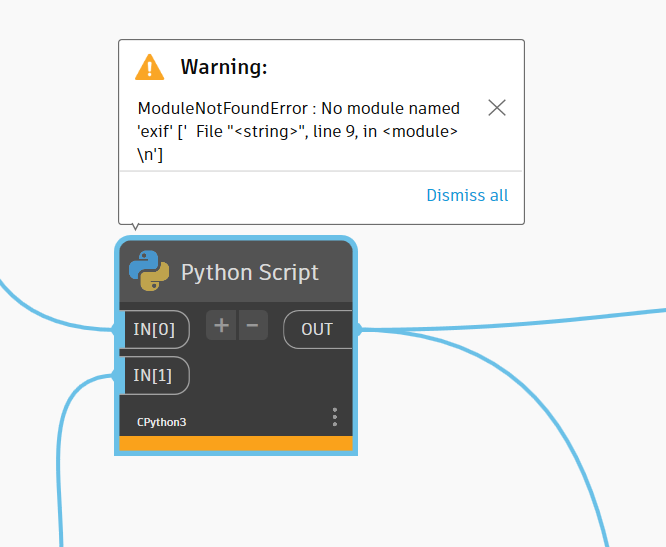
import sys
import os
litte hack because somehow, exif didn’t install correctly
localapp = os.getenv(r’LOCALAPPDATA’)
sys.path.append(os.path.join(localapp, r’python-3.9.12-embed-amd64\Lib\site-packages’))
“”" Import packages “”"
from exif import Image # package to import exif-data
from pyproj import Transformer # package to perform coordinate transformation
import re # needed to get the filename, quiet sloppy
acceptable image formats
formats = (“.JPG”, “.jpg”, “.PNG”, “.png”)
EPSG-Code-From (Image)
EPSG_from = “EPSG:4326” # world geodetic system, GPS Standard
EPSG-Code-To (Output)
EPSG_to = “EPSG:31256” # e.g. UTM32N
“”" Extract necessary exif data “”"
function to convert Degrees/Minutes/Seconds to decimal degrees (account for N/E; S/W)
def decimal_coords(coords, ref):
decimal_degrees = coords[0] + coords[1] / 60 + coords[2] / 3600
if ref == “S” or ref == ‘W’:
decimal_degrees = -decimal_degrees
return decimal_degrees
function to extract necessary exif-data in the desired format
def image_coordinates(image_path):
with open(image_path, ‘rb’) as src: # rb = byte-data!
img = Image(src)
    # get image name using regex (a bit ugly, but exif documentation doesn't help with img.name)
    applyregex = re.search(r"^(.\*\\\\)(.\*)", image_path)
    imgname = applyregex.group(2)

    # 'has_exif' doesn't seem to do the job well enough, check manually instead
    checklat = getattr(img, 'gps_latitude', None)
    checklong = getattr(img, 'gps_longitude', None)
    checkdir = getattr(img, 'gps_img_direction', None)

if checklat **and** checklong **and** checkdir:
    try:
        # Convert coordinates to decimal degree
        coords = (decimal_coords(img.gps_latitude,
                                 img.gps_latitude_ref),
                  decimal_coords(img.gps_longitude,
                                 img.gps_longitude_ref))
        # Transform coordinates using pyproj
        transformation = Transformer.from_crs(EPSG_from, EPSG_to)
        transformation_raw = (transformation.transform(coords\[0\], coords\[1\]))

        # Return results
        return (
        {"Name": imgname,
         "FullPath": image_path,
         "Manufacturer": img.make,
         "Model": img.model,
         "Date": img.datetime_original,
         "Geolocation_lat": coords\[0\],
         "Geolocation_long": coords\[1\],
         "Geolocation_transformed_X":  transformation_raw\[0\],
         "Geolocation_transformed_Y":  transformation_raw\[1\],
         "ImageDirection": img.gps_img_direction,
         "Elevation": img.gps_altitude})
    except AttributeError:
        pass
        # return("Can't process coordinates.")
else:
    pass
    # return("The Image has no EXIF information")
Apply funtions:
image_paths = IN[0]
output_raw =
for image in image_paths:
output_raw.append(image_coordinates(image))
OUT = output_raw