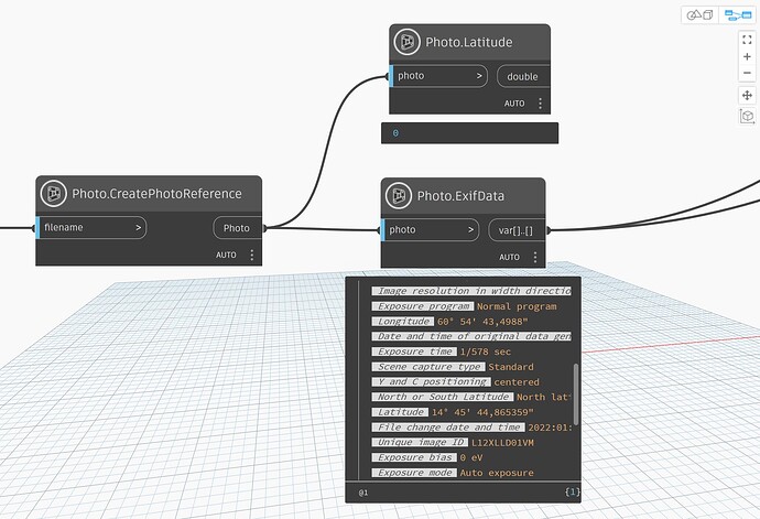
HI, i am trying to ready the data from an image (drone or smartphone) and extract the geolocation information to create a Cogo point with the image name as part of the description. Any ideas on how to get the metadata form the image in dynamo? thanks
You can use The Civil Nodes package in Civil 3D 2025. If you work in older versions, you can find nodes for this in the Civil3DToolkit.
Thank you Anton. i downloaded the civil3DToolKit but i don’t see a node to extract the metadata from the image.
I guess you work with Civil 3D 2025, right?
The Civil3DToolkit does not work in that, and if you try to load it, only some UI nodes are visible. The Photo nodes can’t be shown, because the library is not compatible with Civil 3D 2025.
Happily, the package The Civil Nodes contains also such nodes. That package is loaded in Civil 3D 2025, but not in prior versions.
Thank you Anton. The Civil Nodes work perfectly with image metadata.
Hi @Anton_Huizinga, I’m having issues with this. ExifData works, but Latitude and Longitude gives me 0, while Location says my photo does not contain location. Any idea ? Thank you so much for your help !
Does your drawing have a Coordinate System set?
No it did not. Now the “Location” node gives me a result but it is way off and the result is always the same with any picture. And “Latitude” and “Longitude” nodes gives me 0 everytime.
I think there is still something I’m not using correctly here.
Can you upload the photo?
Unfortunately, it does…
But anyway, I guess your Exif is not correct. If I enter the Lat and Lon in Google, I get a location in Martinique:
I was not sure about the W, if I enter E then the location is in the middle of the ocean.
Is your camera setup correctly?
Yes, this is another picture. I tried with one in France, and one in Martinique so the coordinates you have are correct. The pictures are made with my Samsung phone and there are not that many parameters I can change. And pictures are placed correctly when I add them to maps in my Phone. FYI, here is the GPS data stored in the church photo I shared. This one is in France in a city called Provins.
Try to post the image in a zip renamed to a .txt… or just to a txt (I forget which).
The forum is trying to protect you from accidental location exposure, which is generally a good thing but in this case is blocking you from sharing information.
I am not sure if you use the correct EPSG. Which Coordinate System you usually set in Civil 3D?
If I set Zone 8, it has EPSG:3949 and with the node I get coordinates from the Lat/Lon.
When I create a circle in Civil 3D, I normally can check if the location is ok by showing the background map. But it keeps totally blank. So my guess is that you use the wrong Coordinate System.
That’s a good idea, didn’t think of that ![]()
Meanwhile, I got a photo by mail, so I can test it now.
@Anton_Huizinga, I can confirm your result is correct. But it is not what I have for some reason ![]()
My coordinate system is correct, but the result I have is wrong.
I really don’t get it
The only thing I can imagine is an issue with the conversion of numbers. I see you have commas in the seconds, in my case it is a point:

I’ll have to test with it to be sure, I’ll let you know.
Hi, so I just changed the windows parameter from “,” to “.” and it works. That was the issue ![]()
Do you think it would be possible to upload the node so that it can work in both cases ?


