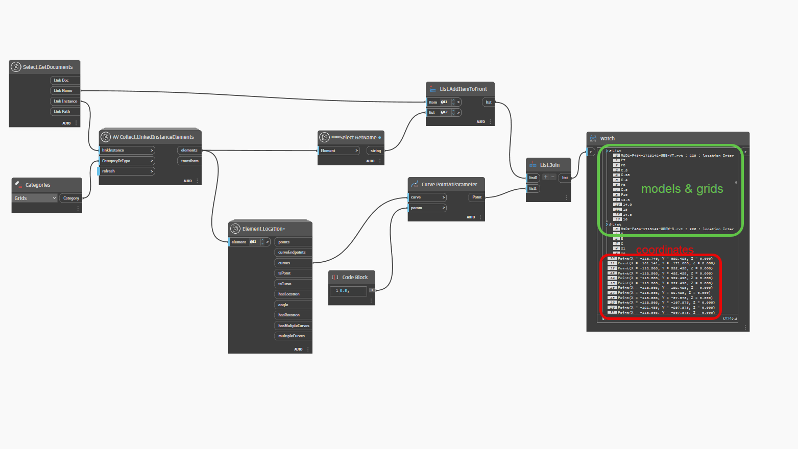
Here’s where I’m at now. Was able to get the grid names listed under their respective linked models. Now I can’t get the coordinates (x,y,z) to show up. Getting closer though!
Good job! ![]()
looks like you are almost there @michael79
It’s easy to randomly change list levels in various nodes until it looks right- but it is better to logically work out what you want the final data to look like, then think back through each step needed to achieve this.
For example- do you want the CSV rows (i.e each column) to be:
Revit link name>>grid name>>start point x>>Start point y>>start point z>>end point x>>end point y>>end point z
or
Revit link name>>grid name>>[start point x,y,z]>>[end point x,y,z]
or something else
1 Like
Hey,
Doing great!
Just something you might be interested in, with these kinds of operations, I think a dictionary can be a good way to go… I find it easier if you start to get nulls and are trying to keep track of a big graph where things shift and move.
Hope that helps,
Mark

3 Likes

2 Likes
@bvs1982 Wow thank you I will give this a shot today! I really appreciate your help and will return with any questions/comments I have.
@bvs1982 This script is almost there! There are, however, a few important things that need to be modified:
The X & Y points are getting calculated by the individual linked model Project Base Points instead of the host model base point (or internal origin. Just need a static place to measure all linked files from). The individual Project Base Points are all in different locations, causing grid lines that are aligned to show different X or Y values, depending on their orientation. This is causing a discrepancy between grid line measurements in the Excel file.
So if Linked Model 1, GL1 is measuring 10’ from it’s own Project Base Point and Linked Model 2, GL1 is aligned with Linked Model 1, but measuring 12’ from it’s Project Base Point, then the value returned has a discrepancy of 2’ even though they are actually aligned.
I hope this makes sense?
Yes. Hate you use the imperial system though.
Have to think about a solution though.
Maybe someone else has a good idea.
PS
I don’t know what field you’re in or why you have 50+(!) linked models, but maybe it is time to think about the workflow.
To me every model should have the same internal origin, project base point and survey point. Saves a lot of headaches.
1 Like
I’m a BIM Manager and work with very large projects with multiple design teams/disciplines.
I agree they should all have the same base points, but with disparate models and design teams that is nearly impossible.
I would hope there would be a way to tell Dynamo to measure from an internal point in the host model…if possible.
Just FYI.
Here we establish things like what the project base point should be and such, for a project, between all disciplines and 3rd parties before we even start working on a plan and document that.
PS
I am a BIM coordinator.
Yes, totally agree. However, I’m coming into this project near the end of design, as is the case with most projects we do, so delegating these things is difficult at this stage. I wish coordinating these types of things would be easier/smoother, but unfortunately, here we are.
Although the Project Base Points are in different locations, the Survey Points are aligned. All models are on Share Coordinates.
I can’t be much of a help for now.
I am off till Tuesday.
So maybe someone else can pitch in.
@bvs1982 No problem and thank you again, have a good time off!
Also, I realized it’s actually the Internal Origin that differs between models, and that is where the X, Y measurement discrepancy is coming into play, not the Project Base Point. Hope that clarifies things a little more.
Get X Y calculated from de survey point? I did not try that. But if the survey point are right and the base points are different??? How can you build??? They choose the base points on different grids crossings?
I think read both points (if possible) and do the math (but don’t ask me for it)
Good luck nice subject.
Greeting Jan-Willem
@jwroelofs Thanks for chiming in. I mispoke…the Project Base Points and Survey Points are all in the same location (thank goodness!) The Internal Origin of the different linked models is what is different. Dynamo appears to take measurements from the Internal Origin of each linked file, rather than the Internal Origin of the host file. That is what’s causing the discrepancy.
I tried using the Convert Origin node from Genius Loci, but I still get the same measurements for some reason.
Hopefully someone smarter than me can help out lol!
You need to transform the grids from the internal coordinate system to the common coordinate system (survey point or project base point). Get the desired coordinate system, and use a Geometry.Transform to put everything into the same location and orientation which will allow coordination review.
1 Like
uh-oh.
You probably know this already, but way easier to setup properly in the first place- otherwise forever chasing your tail
Creating a master file, from which everyone else acquires coordinates and copy-monitors grids is the first thing I do
1 Like
Hello, thank you for sharing your issues. I’ve started working on the exercise, but there are a few things I still need to understand. If you want to check whether all the links are aligned, you need at least one correct link to use as a reference for comparison

Coordinate systems aren’t really my strong suit ![]() , but i think this is what @jacob.small meant(?).
, but i think this is what @jacob.small meant(?).

EDIT
I am not getting the expected results when trying this ![]() .
.
So i must be doing again. But again, not my strong suit ![]() .
.
I moved everything 5000mm in both directions in one of our Linked Models.
The top model is from a 3rd party.
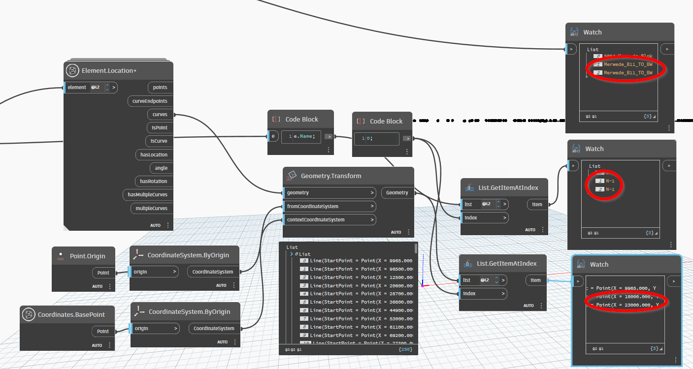
@jacob.small Can you tell me what i am doing wrong maybe?